


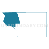
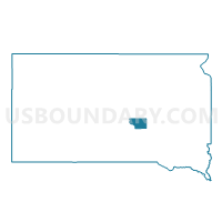
VTD-precinct 3, Buffalo County, South Dakota
About
Outline

Summary
| Unique Area Identifier | 667067 |
| Name | VTD-precinct 3 |
| County | Buffalo County |
| State | South Dakota |
| Area (square miles) | 98.81 |
| Land Area (square miles) | 90.02 |
| Water Area (square miles) | 8.79 |
| % of Land Area | 91.11 |
| % of Water Area | 8.89 |
| Latitude of the Internal Point | 44.12403170 |
| Longtitude of the Internal Point | -99.44336940 |
Maps

Graphs
Select a template below for downloading or customizing gragh for VTD-precinct 3, Buffalo County, South Dakota


Neighbors
Neighoring Voting District (by Name) Neighboring Voting District on the Map
- VTD-precinct 1, Buffalo County, SD
- VTD-precinct 2, Buffalo County, SD
- VTD-precinct 4 Oacoma, Lyman County, SD
- VTD-precinct 5, Hyde County, SD
- VTD-precinct 7 LowerBrule, Lyman County, SD
Top 10 Neighboring County Subdivision (by Population) Neighboring County Subdivision on the Map
- Crow Creek UT, Buffalo County, SD (1,736)
- Lower Brule UT, Lyman County, SD (1,481)
- Crow Creek UT, Hyde County, SD (89)
Top 10 Neighboring Place (by Population) Neighboring Place on the Map
Top 10 Neighboring Unified School District (by Population) Neighboring Unified School District on the Map
- Chamberlain School District 07-1, SD (6,044)
- Lyman School District 42-1, SD (2,974)
- Highmore-Harrold School District 34-2, SD (1,821)
Top 10 Neighboring State Legislative District Lower Chamber (by Population) Neighboring State Legislative District Lower Chamber on the Map
Top 10 Neighboring State Legislative District Upper Chamber (by Population) Neighboring State Legislative District Upper Chamber on the Map
Top 10 Neighboring 111th Congressional District (by Population) Neighboring 111th Congressional District on the Map
Top 10 Neighboring Census Tract (by Population) Neighboring Census Tract on the Map
- Census Tract 9402, Buffalo County, SD (1,912)
- Census Tract 9401, Lyman County, SD (1,480)
- Census Tract 9767, Hyde County, SD (1,420)
Top 10 Neighboring 5-Digit ZIP Code Tabulation Area (by Population) Neighboring 5-Digit ZIP Code Tabulation Area on the Map
- 57325, SD (3,054)
- 57339, SD (1,525)
- 57548, SD (1,380)
- 57345, SD (1,238)
- 57569, SD (445)
- 57346, SD (68)